Illawarra, South Coast battered by heavy winds, rain storms overnight

Bugle Newsroom
02 July 2025, 2:45 AM
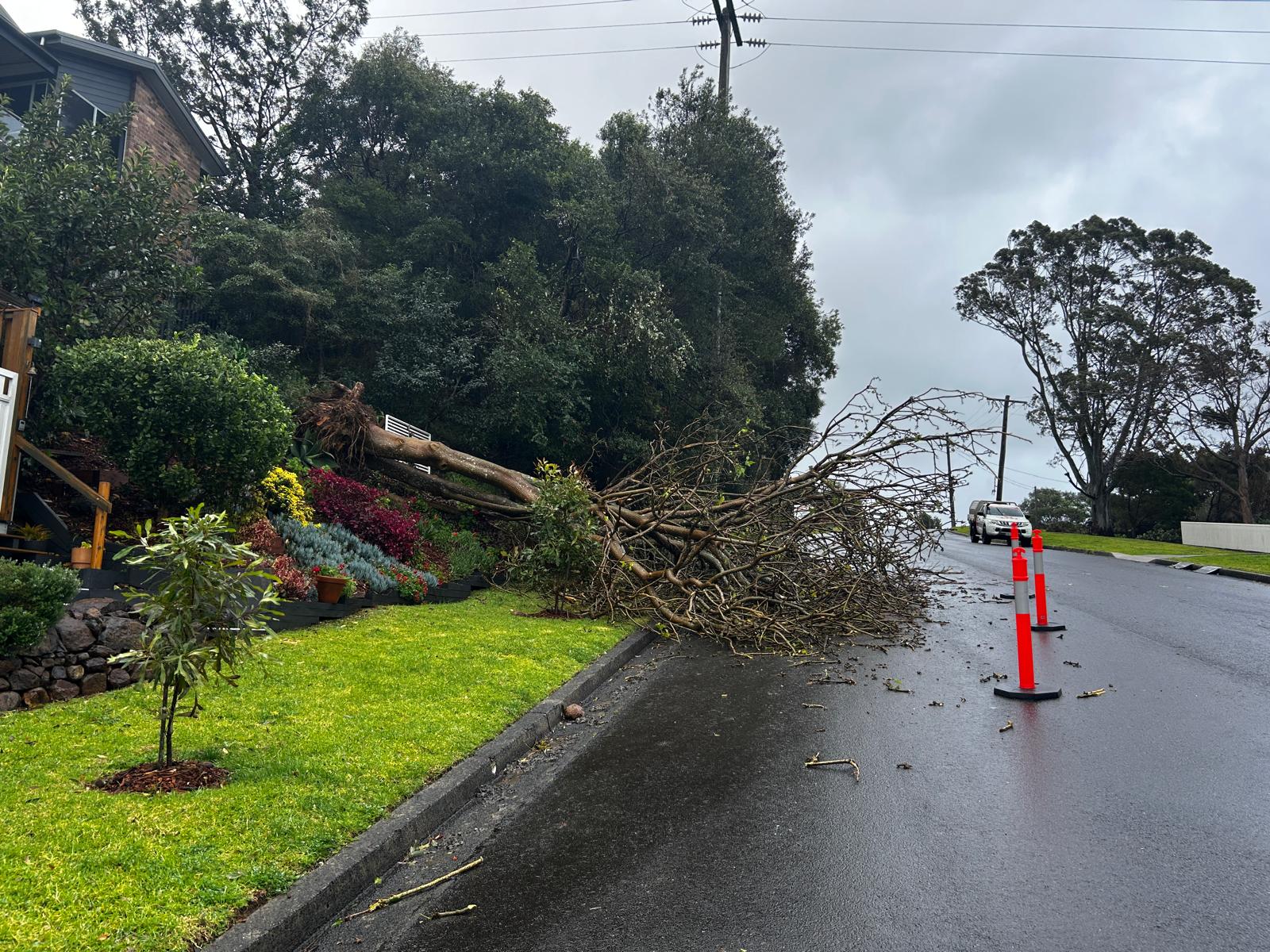 A fallen tree in Kiama at Barney Street. Photo: The Bugle
The Illawarra and South Coast has been battered by overnight rain storms and heavy winds with emergency services working overtime to respond to calls for help.
A complex low pressure system brought heavy rain and damaging winds to the Illawarra, South Coast, Newcastle and Sydney with some areas recording over 200mm of rain.
Kiama has copped 133mm of rain in the 24 hours leading up to 9am on Wednesday with Foxground receiving 148mm and Broughton Creek 191mm.
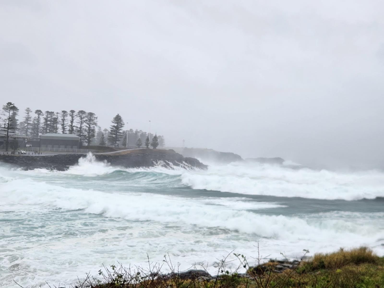
Huge waves crash into the Kiama coast north of Blowhole Point. Vision: The Bugle
Further south, 170mm has fallen in Currarong and 207mm at Bawley Point.
The Bureau of Meteorology has forecast that the South Coast could receive another 50mm-100mm overnight on Wednesday into Thursday morning.
SES crews are continuing to respond to severe weather along the NSW coast, from the Mid North Coast to the Far South Coast.
The majority of incidents overnight have involved fallen trees, powerlines and damaged roofs.
NSW SES has responded to over 2320 incidents, with most in the Hunter, Sydney Metro area, Illawarra and South Coast.
More than 1200 volunteers have provided assistance, including assisting beachside properties with sandbagging efforts to protect them from coastal surge on the hightide overnight.
Flash flooding remains a key concern from Sydney to the South Coast on Wednesday.
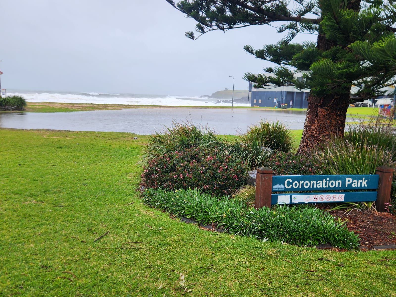
Coronation Park has yet again flooded. Photo: Matty Taylor
The Bureau of Meteorology has issued a gale warning for the Illawarra, Batemans and Eden coasts, as well as Sydney enclosed waters and the Coffs, Macquarie, Sydney and Hunter coasts.
Widespread rainfall totals reached 150mm overnight, with falls exceeding 200mm at Ulladulla.
Emergency Warnings have been issued in Burrill Lake, where about 200 properties are impacted by flooding, some of them to over floor level. Sanctuary Point residents are also under an Emergency Warning.
Flood rescue crews responded to a surge in rescue incidents around Shoalhaven overnight as flash flooding swept through the area.
More than 17,000 homes and businesses have been left without power in the Shoalhaven, Illawarra, Southern Highlands, Blue Mountains and Western Sydney.
Endeavour Energy has announced there are more than 300 fault sites across large parts of those areas that its crews need to inspect, make safe and repair.
The worst-hit areas include Kiama and Jervis Bay, with damage extending inland into the Southern Highlands.
Power was out in many parts of Kiama and Jamberoo with Endeavour Energy announcing restoration work had been completed by 12.30pm on Wednesday.
Kiama and Gerringong libraries, as well as the Kiama Family History Centre and The Pavilion have been closed on Wednesday with other Council sites operating with reduced services, including the Administration Building, Minnamurra Waste and Recycling Centre and Kiama Leisure Centre.
There have been numerous power outages in the Kiama LGA with several shops closing early on Tuesday and not being open on Wednesday.
Surf Beach at Kiama. Photo: Matty Taylor
Jamberoo Pub closed early at 3.30pm on Tuesday to make sure staff and patrons did not have to travel to and from the venue in the treacherous conditions.
Kiama High School and Vincentia High School are operating under minimal supervision on Wednesday.
Road closures are in place on the Princes Highway near Ulladulla as well as Taylor Road at Albion Park, Swamp Road from Dunmore to Jamberoo and Windang Road at Primbee.
The Illawarra Highway between Tongarra Road and the Princes Motorway has been reopened after it had been closed on Wednesday morning.
At midday on Wednesday, NSW SES advised people in the Sussex Inlet to prepare to evacuate due to rising minor flooding if they live in the following areas:
River Rd
Wunda Ave
Ellmoos Ave
Jacobs Drive
Poole Ave
Cater Cres
Banksia St
Fairview Cres
Nielson Lane
Christine St
Laguna Lodge
Riviera, Riverside and Seacrest Caravan Parks
NSW SES Acting Assistant Commissioner Allison Flaxman said flash flooding is a significant risk with this weather system and urged the community to take caution on roads.
“These incidents are a timely reminder that roads are slippery, and conditions can become dangerous quickly,” Acting Assistant Commissioner Flaxman said.
“Please never drive, walk or play in floodwaters. If you do come across a flooded road, turn around and find an alternative route.”
The Bureau of Meteorology has issued an initial minor to moderate flood warning for the Hawkesbury and Nepean Rivers at Menangle and Camden, as well as an initial minor flood warning for the St Georges Basin at Sussex Inlet.
Assistant Commissioner Flaxman also urged those in low-lying areas to know their flood risk and have a plan in place.
“That means understanding what you will do if your area floods and where you will go if you need to evacuate,” she said.
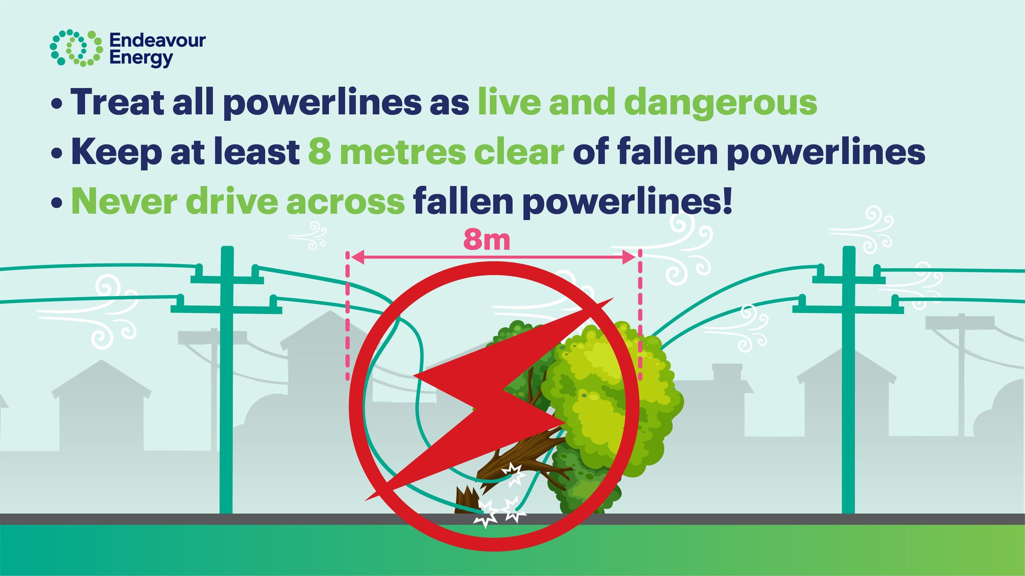
“We also remind community members to keep clear of fallen trees and powerlines as our crews work to clean up storm damage.
“We have deployed personnel, high clearance vehicles and aviation assts into the areas of impact."
There are 28 warnings current, including seven emergency warnings.
Residents of Wamberal and North Entrance were asked to evacuate due to dangerous waves which could significantly damage buildings. NSW SES Volunteers door knocked the affected residents and advised them to evacuate before high tide as a precautionary measure to ensure safety of residents.
Severe weather is forecast to continue throughout today, before easing from Thursday as the low moves east into the Tasman Sea.
“This weather system is complex and dynamic and we will continue to issue warnings as the situation evolves,” Assistant Commissioner Flaxman said.
“Stay up to date on the latest warnings and advice via the Hazards Near Me app and set up a watch zone for your local area, or visit the NSW SES website.”
When travelling in these coastal areas, the SES advises motorists to stay alert for flash flooding over roads and to never drive through floodwater as it is dangerous and unpredictable.
Damaged buildings, fallen trees and downed powerlines should be avoided.
Rain and strong winds are expected to continue on Wednesday (2 July), before easing from Thursday as the system moves into the Tasman Sea.
NSW Police Force, Marine Area Command advise that:
- People should consider staying out of the water and avoid walking near surf-exposed areas.
- Rock fishers should avoid coastal rock platforms exposed to the ocean and seek a safe location that is sheltered from the surf.
- Boaters planning to cross shallow water and ocean bars should consider changing or delaying their voyage.
- Boaters already on the water should carry the appropriate safety equipment and wear a lifejacket.
- Boaters should remember to log on with their local Marine Rescue radio base, via VHF Radio or the Marine Rescue APP, and consider their safety management plan.
📞 For emergency help in floods and storms, call the NSW SES on 132 500. In life-threatening situations, call Triple Zero (000) immediately.
NEWS